Resilience Analysis and Planning Tool (RAPT)
Total Water Level and Coastal Change Forecast Viewer
Rapid Vulnerability & Adaptation Tool for Climate-Informed Community Planning
Scenario Planning for Crops and Cattle
Resilient Agriculture: Weather Ready Farms eFieldbook
Hurricane Preparation and Recovery Commodity Guides
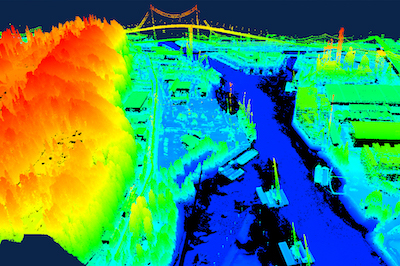
Introduction to Lidar
Source:
Difficulty scale:
Image:
Type of Training:
Category:
Module Description:
This course, designed for those curious about what lidar is and why it is useful for management decisions, provides quick and flexible access to several topics needed to understand the lidar landscape. The course features engaging video and audio, optional knowledge checks, a final quiz with certificate, and assistive services for those with disabilities.
Working with Lidar - Module 1 - Define and Decide
External Link:
Source:
Module time (hr:min):
1:00
Difficulty scale:
Image:

Type of Training:
Category:
Module Description:
This suite of modules helps you complete the first four steps in the process of working with lidar data. Whether deciding if lidar is the right technology, locating and assessing data, or contracting these services, these modules offer grab-n-go quick references, progressively detailed information, examples, expert tips, and tutorials.
Module 1: Define and Decide – Use a checklist to define the issue and a decision tree to decide if lidar is right for your project
Modules 2, 3, and 4 are planned for release from Summer, 2021 through Winter, 2022.
Region:
